While ticking off bustling, iconic sites on a trip is satisfying, taking the road less travelled has its own unique appeal.
A lack of crowds (apart from the odd sheep or flock of birds) and a sense of the wilderness really come into their own for an awe-inspiring journey. We've rounded up the most remote places in the UK to explore these wild isles.
- The best UK UNESCO World Heritage sites to visit for unforgettable days out
- Want to own your own island like Richard Branson? This uninhabited remote Scottish isle is now for sale
- Britain's best crowd-free holidays
Most remote places in the UK
Mountains of Mourne, County Down

Take a look at a map of Northern Ireland and it’s clear there are only four places where it might be possible to achieve isolation: in the middle of Lough Neagh, which may prove impractical, or in the Antrim, Sperrin or Mourne Mountains. Of these, the least penetrable is the Mourne in County Down. There’s just a single B-road passing through.
Located in the south-east corner of the province, and protected by the Irish Sea, the range is mostly granite. It has 30 peaks of 500m or more, the loftiest being Slieve Donard which, at 850m, is Northern Ireland’s highest mountain. The lower climes consist mainly of farmland, forests and reservoirs. If you’re up for a challenge but prefer not to be troubled by the intricacies of navigation, you could try walking the Mourne Wall.
Constructed over a period of 18 years a century ago to keep animals from contaminating the water supply, it passes over 15 of the Mourne’s mountains, including Slieve Donard.
The seaside town of Newcastle makes an excellent base from which to explore the mountains. Just be careful where you’re treading. Slieve Lamagan, for example, is actually a petrified witch, while Slieve Bearneagh is partly composed of a giant.
Berney Arms railway station, Norfolk

One of the few railway stations in Britain that are inaccessible by road, and named after a similarly difficult-to-reach pub, Berney Arms opened in 1844. It’s stuck out in the middle of marshes and trains rarely stop there – we named it one of the best request stop train stations in the UK. The single platform is often claimed to be Britain’s shortest. So why is it there at all? Well, the establishment of a halt ‘in perpetuity’ was demanded by one Thomas Trent Berney – his condition for selling the land to the Yarmouth and Norwich Railway so they could build a line through here.
Sadly, the nearby pub on the banks of the River Yare has closed down. The community – which once ran to 11 families, a chapel and post office – is now down to just a handful of people and Norfolk’s tallest windmill.
But if you want peace and come prepared for the wind that cuts across the marshland and has cut to shreds every shelter that’s ever been built on the platform, Berney Arms station is a relaxing location. It overlooks an RSPB reserve and the Halvergate Marshes Site of Special Scientific Interest, so over winter you can keep an eye out for interesting bird species such as Bewick’s swans and pink-footed geese. Just keep the other eye on the timetable.
Cow Castle Iron Age hillfort, Somerset

Not to be confused with its namesake in South Lanarkshire, Cow Castle sits alone on the top of a knoll on Exmoor. Some 60m below flow the River Barle on one side and its tributary the White Water on the other, almost turning the hillock into an island.
In technical terms this is a ‘slight univallate hillfort’, the sort that archaeologists believe could have had numerous purposes, such as an enclosure for livestock, a refuge or a permanent settlement. Like other hillforts in Exmoor it’s relatively small – the area enclosed by its rampart and ditch measures just under one hectare.
Cow Castle is extremely well preserved, the only modern damage to it being a gap in its rampart that may have been caused by those working a now-defunct quarry below. Four platforms have been detected where buildings would have stood, and there are probably others yet to be discovered.
The only way to experience this little slice of the Iron Age is to walk the Two Moors Way, which passes right beneath it as it heads between the villages of Simonsbath and Withypool. On the way, you’ll enjoy some cracking views of Exmoor’s mishmash of humps and bumps, a landscape somehow gentler than Dartmoor or Bodmin.
And if you’re after food for thought for the journey? The myth attached to the hillfort is that it was constructed by fairies to defend themselves against the planet itself. Clearly life as a fairy isn’t quite the idyll it looks.
Kielder, Northumberland

Lost in the midst of 239 square miles of forest and over six miles from the nearest B-road, the village of Kielder cuts a solitary figure. Since 1982, its population of around 200 has lived at the head of Kielder Water, which holds 200 billion litres of the stuff, took two years to fill and is northern Europe’s largest artificial lake. Its construction wiped out any chance of Kielder’s railway line reopening and also drowned the village school, which might have pleased the children at least.
The history of Kielder is relatively brief, beginning in 1775 when the Duke of Northumberland built himself a hunting lodge there called Kielder Castle. Some 15 years later, the lodge was the scene of an epic football match between the menfolk of Tynedale and Redesdale.
The village lies in the Kielder Water & Forest Park, planet Earth’s fourth largest Dark Sky Park. The area is purported to enjoy the lowest levels of light pollution in England, making Kielder and its nearby observatory a hotspot for stargazers. Many years ago though, the settlement was a magnet for a different visitor. Its location at the western end of the Cheviot Hills, just three miles from the Scottish border, made it an ideal stopping-off point for those wishing to smuggle whisky into England.
- How to see the Northern Lights in Britain
- You don’t need a telescope to see into space and marvel at starry wonders. Here are 6 naked-eye night sky sights to look out for
Today, despite its diminutive size, Kielder runs to a post office, petrol station, pub and 24-hour ‘Minotaur Maze’, for what self-respecting village doesn’t?
Trig point, Derbyshire
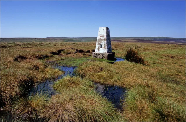
In the High Peak area of the Peak District, between Kinder Scout and Howden Moors, lies West End Moor. It’s a little frequented corner of the National Park, crossed by a single path that’s not even accorded the little green dash of the public footpath on OS maps. The path leads to a lonely trig point with wonderful moorland views.
About 6,500 of these small concrete pillars – known as triangulation stations – scatter the nation. The first trig point was built in 1936 and collectively they helped the Ordnance Survey produce some of the most accurate maps of their day. Though not necessarily located on the summits of hills and mountains, each one has sight lines to at least two others, so you’re all but guaranteed a good panorama of the countryside.
A visit to West End Moor’s trig point will require about four miles of rough-ish walking. First you need to get yourself to the point where the Snake Road (A57) crosses the River Alport, about six miles south-east of Glossop. Take a public footpath past Alport Castles Farm and then climb up to a ridge called Alport Castles. Here the path turns sharp right to drop off Birchin Hat; continue straight on to the trig point and pay homage to a slice of the nation’s heritage.
Smalls Lighthouse, Pembrokeshire

Stranded 20 miles off the coast of south-west Wales, this lighthouse is over 40m high and, automated since 1987, it guides shipping safely past the Smalls, the rocks on which it stands.
It was the scene of a particularly grim episode around 1801 – now known as the Smalls Lighthouse Tragedy – when one of the lighthouse keepers on the lighthouse died in a freak accident. The incident caused Trinity to change the regulations to ensure it never happened again.
Foula, Shetland

When it comes to Britain’s inhabited islands, it’d be hard to beat Foula if you’re looking for isolation. Bobbing about in the Atlantic, it’s a full 15 nautical miles off the west coast of the Mainland of Shetland. With phone reception exceedingly patchy, it’s appreciatively cut off from the world and its myriad troubles.
The little isle was first inhabited five millennia ago and today is home to fewer than 40 hardy souls. There are three cottages let to visitors (check out the ‘General Information’ section at Foula Heritage for more information) but, as you might expect, further facilities are somewhat thin on the ground. A post office is open six hours a week but there’s no shop.
And while the island does have a short airstrip, by far the more exciting way to arrive is to take the twice-weekly 12-passenger ferry for the two-hour voyage from Shetland. Astonishingly, a ticket will set you back a mere £2.80. If you’re bringing your car with you, that rises to a whopping £16.50.
Fellow visitors to the island include puffins, guillemots, kittiwakes and seals, and you’ll see Shetland ponies and the island’s very own breed of sheep too. However, do be warned – in contrast to most of Great Britain, humans are not the apex predator on Foula. You’ll discover this as soon as you venture too close to the nest of one of the Arctic skuas or bonxies (great skuas) who inhabit the island. Large and well armed, these feisty birds attack the heads of intruders, so you’d be advised to hold a stick above yours (so that they dive bomb and attack the top of that instead) and beat a hasty retreat.
Kilmory phone box, Ardnamurchan
On the north coast of the sparsely populated Ardnamurchan peninsula, some 50 miles from the nearest town (Fort William), lies a small collection of houses known as Kilmory. It’s a place of extreme Highland tranquillity.
However, Kilmory possesses one feature that has plucked the hamlet from obscurity: one of Britain’s most remote and photogenic phone boxes. Standing alone by a bend in the road, as if keen to thumb a lift, it enjoys a backdrop of fields, shoreline, the sea and the isles of Muck and Eigg. Judging by the many photographs of it to be found online, it’s all but impossible to take a poor picture of it.
Unlike the majority of the nation’s fast dwindling phone boxes, the one at Kilmory actually functions, although the phone only takes phonecards, items with which anyone under the age of 30 may not be familiar.
Apparently, they can be purchased in Kilchoan, about six miles away (the village also provides the nearest café, Puffin Coffee). Despite the lack of mobile coverage in the area, British Telecom did attempt to close the box down in 2017. A campaign by locals caused them to reinstate it the following year. And in case you were wondering, yes, Kilmory phone box does have its own Facebook page.
Tan Hill Inn, North Yorkshire

The most remote pub also takes the title of the UK's highest pub. Famous for its inevitable lock-ins that occur when visitors arrive before a flurry of snow, you'll find the Tan Hill Inn on an exposed stretch of the Pennine Way. Its nearest settlement, the small village Keld, is around four miles away (follow our walking guide from Keld to Tan Hill Inn) – making this 17th century watering hole an extremely welcome sight.
Soar y Mynydd chapel, Ceredigion

Lost in the Cambrian mountains, sheltered by the steep and narrow valley of the River Camddwr, it’s no wonder that the National Churches Trust, who look after Soar y Mynydd, claim that it’s the ‘remotest chapel in Wales’.
Many of Britain’s chapels and churches can be found in lonely places because the community that once surrounded them has disappeared. But this is not the case with Soar y Mynydd.
The Calvinist Methodist chapel was built in 1822 at the instigation of local minister Rev Ebenezer Richard to serve the farming families that were scattered around this quarter of the Cambrian mountains. Constructed from rubble and stone salvaged from ruined farmhouses or plucked from the riverbed, it was an isolated outpost of a Welsh church movement that had seceded from the Church of England just over a decade before and which became popular in the 19th century.
However, by 1968, the congregation numbered just two. Saved from closure, the simple chapel hosts Welsh-language services held on the last Sunday in August.
Should you wish to visit, Tregaron (to the north-west) is the closest village, and Llanwrtyd (to the south-east) the nearest railway station, involving a trip on the scenic Heart of Wales line. There’s no bus to the chapel so, if you’re going under your own steam, it’s a seven-mile hike or bike from Tregaron and 15 miles from Llanwrtyd station – and glorious terrain all the way from either.
More UK travel inspiration
- Are these the most rejuvenating places in the UK? The best destinations to beat the winter blues
- Best walking holidays: Hiking routes, guided tours and accommodation
- UK's best follies to visit, from fairytale turrets and towers to temples
- Fill your summer with exciting outdoor adventures and challenges, from shark spotting to conquering fears